Monday, February 25, 2013

2008: Calistoga Gets Scenic Loops!

It may sound trivial, but it was a big deal back in 2008. After months of discussion, Calistoga's Bicycle Advisory Committee (BAC) persuaded the City that way-finding signs would be helpful to visitors wanting to take a bike ride around town. One determined member of the BAC invested hours with a barely cooperative ex-employee of Public Works (nameless and long gone) to personally assist with placement of  Bike Route signs around town, and to define two color-coded riding loops.
Red Loop - Entering Cedar Street from Cyrus Creek Bike Path


The Red Loop is the route for exploring the west side of town.
Riding along Calistoga's Napa River bike route.


The Yellow Loop is the route for seeing the east side of town.
Heading south on the Yellow Loop
The results are obviously helpful. But why was it such a struggle? Hopefully those days are just ancient history.


Sunday, February 24, 2013

Back to the Story . . . Grant Street

Not sure when this was created (90s my guess), but if you head downtown from Tubbs Lane on Grant Street, just as you pass Mora Avenue you will find this.
Looks like a Class II Bike Lane!

Here are typical users of this lane.
Mom, baby, and a couple of tykes behind

A Tyke Lane?
Scootin' after Mom

Here's why they ride on the wrong side.
There is no option. A half-Class II?

At the corner, the signage beckons.
Right onto North Oak

The half-Class II bike lane continues.

Maybe it's really a just a low budget sidewalk.


Friday, February 22, 2013

Exciting News! Calistoga City Council Approves Grant Resolution

Last Tuesday, February 19, 2013 the Council passed a resolution 5-0 to authorize staff to apply for a $50,000 grant from the Bay Area Ridge Trail to pay for part of the engineering for the Fairway Extension project. Here's a picture of the mayor calling for the vote.
Mayor Canning, surrounded by the Council


This grant will make the project 'shovel ready' which means it is far more likely to qualify for Federal and State funding. The project itself is extending the Class I Washington-Dunaweal Bike Path to Lincoln Avenue, along the old railroad right of way.

Before the vote, a member of the Calistoga Bicycle Advisory Committee urged the Council to support the resolution. If you want to see the 6 slides, click here or on the caption below.

BAC Presentation to Council


Basically this is free money for Calistoga which will enable Calistoga to get even more free money to build a $1.2 million project with no City contribution. If you thought this would not be controversial, you would be thinking wrong. 

A couple of residents spoke against bicycling and bicyclists  in general (not the resolution), basically painting a picture of terror and/or horror which is grossly overstated by the following R-Rated video . . .  removed it after some reflection.
 Anyway, it seemed funny at the time, and you can find it pretty easy if you want 

(remember, you've been warned):


Sunday, February 17, 2013

2006: Fast-Forward Another 14 Years -
The Washington-Dunaweal Bike Path

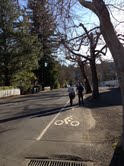
The City of Calistoga took the third big step in its bicycle network when it dedicated a 1 mile multi-use path in 2006. The path connects the end of Washington Street to Dunaweal Lane. You've got to look twice to realize you may use this road by entering it on the left (note the arrow).
The Gateway to the Washington-Dunaweal Bike Path


 Bicyclists, walkers, and joggers appreciate that the City lets them use the access road to the sewage treatment plant for exercise. But wait, wasn't it built with money from the Caltrans Bicycle Transportation Account? 
A multi-use path.


 An insight into how Public Works keeps house. Just keep riding.
View from your bike of the Corporation Yard.

Sure are a lot of signs with advice for users of the path. Not exactly welcoming.
Mt. St. Helena in the distance.


 Who would wander off into this anyway?
More debris and another warning.


Is it really Art?
More installations and signs.


The bridges were resurfaced last year to be safe for bikes. Used to be wide grooves that caught narrow tires and caused some nasty spills. The safety upgrade is appreciated!
First of 2 bridges on the trail.

The path takes you by a series of sewage treatment ponds that don't smell bad most of the time.  As you go by check out the geese, ducks, egrets, and turtles.
Sewage Treatment Pond.


Currently there are no amenities for trail users, but this spot has been suggested as a great spot for a bench as a rest stop for the many senior citizens who enjoy the path.
Site of future bench for walkers.


The path is really quite nice once past the first bridge.

Heading south toward Dunaweal.


Just across the bridge the path veers to the left around the sewage treatment plant.
Approaching the 2nd bridge.


Someday maybe residents and visitors will be able to stop and take time to relax along the trail too.

Picnic table for workers at the plant.


Once upon a time this was one of the most controversial bits of architecture in Napa Valley. Now Michael Graves' work seems very much at home.

Near the end of the trail is Clos Pegase.


Just across the street is the entrance to Sterling Vineyards and is the point where the Washington - Dunaweal Bike Path will some day link up to the Napa Valley Vine Trail, providing a safe way to ride or walk to Napa Bothe State Park, St. Helena, and eventually all the way to the Vallejo Ferry.

Approaching Dunaweal Lane.
In fact this path will be the northern end of the Vine Trail.  A little upgrade is in order  . . . perhaps to the standards used in the first Class I trails of Calistoga?

1993: Ten Years Later - Maxfield Bike Path 

The second bit of cycling infrastructure for Calistoga was built in the early '90's.  The Maxfield Path was built to link the Centennial Circle development with the Riverlea neighborhood. Riders and walkers enjoy a short stretch of the
Napa River.
Entry to Maxfield Bike Path from Centennial Circle

Here's the bridge over the Napa River (a creek at this part of the valley) and just beyond you can get a peek at the
golf course.
Maxfield Path Bridge over the Napa River


Just after after crossing the Maxfield Bridge, look to the right and note that someone apparently dreamed of a river trail, and actually put part of one in at Heather Oaks Park.
It goes about a hundred yards.
Nice idea!
Heather Oaks Park


Monday, February 11, 2013

1983: Calistoga's First Bicycle - Pedestrian Path


Such promising start, even though it extends barely 1/4 of a mile . . . take a look:


A beautiful bridge over Cyrus Creek

And there's more:

A parklet with shaded benches, drinking
fountain, and a garbage bin.

But that's not all:

 Light bollards help you
find your way safely after dark.

And best of all:

People use it to get around.
Some even ride with their kids.

Saturday, February 9, 2013

Gateway to Town . . . Looks Promising


Since 2009 this sign has been nailed to the city limit sign. And before that, there was a really faded one that dated from the late '90s.  The sign suggests some sort of special experience is in store for people riding bikes in town. Does Calistoga deliver on that promise? Not always and not as one might expect.

This blog explores Calistoga from a bicyclist's point of view. Not just showing the good, the bad, and the ugly (although there will be some of that), but showing what could be done . . . for the benefit of the people that live here and for visitors too. After all, a promise made is a debt unpaid, right?